Info Blue Mountains Railway Pages
Katoomba Cable Railways
3 Sisters, Blue Mountains, Australia.
Katoomba Scenic Railway & mining tramways

Blue Mountains Australia Railway History
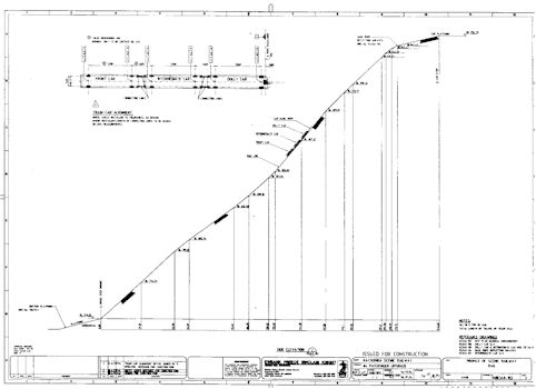
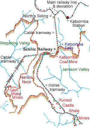
History

The world famous Katoomba Scenic Railway was originally part of a network of tramlines built to bring coal and kerosene shale from mines up to the main railway.

John Britty North registered "Katoomba Coal Mine" in 1872. In 1882, a loading platform called North's Siding was opened near Gundar St, and a network of tramways developed from there. These included what is now the Scenic Railway.

Locating kerosene shale at Ruined Castle, he registered "Katoomba Coal & Shale Co. Ltd" in 1885. German engineers were hired to construct an aerial ropeway. Known as the "Flying Fox", it ran from the Ruined Castle, across the Jamison Valley, to the engine bank (near the upper terminus of the Scenic Railway). It collapsed after only a six months, the wreckage is still strewn across the valley.  The company soon went into liquidation.

The Australian Kerosene Oil & Mineral Company took over the Glen Shale Mine in the Megalong Valley &, soon after, the Ruined Castle mines. They decided to concentrate their efforts on the Glen Shale Mine. A sizeable miners settlement sprang up in Nellies Glen with general store, bakery, butchery & public Hall.

A miners track, now the Golden Stairs, ascended the eastern side of Narrow Neck from where a track of sorts  led into Katoomba. Another precipitous descent, Dixon's Ladder, led down to the Nellies Glen hotel.

By 1895 both mines were winding down, & Katoomba's shale oil industry was abandoned by 1903.

In 1925, the Katoomba Colliery was registered, with the aim of re-opening the coal mine at the base of the cliffs. Coal was to be sold to the Katoomba Electric Power-house, and to hotels, residents etc. They set about rehabilitating the cable-haulage way from the cliff-top to the valley below; this would later become the Scenic Railway.

The first passengers, a group of weary bushwalkers, were carried in a coal wagon, in the late 1920's. Management realised the financial potential, and had seats built onto some coal skips.

The Depression, & the closure of the Katoomba Electric Power-house, spelt the death of the coal mine. From about 1933, the company concentrated on the tourist trade, constructing a passenger car called  Mountain Devil.

Further history to be added.


Katoomba Scenic Railway Facts

World's steepest incline railway (Guiness Book of Records 1997-8)
Maximun gradient: 52 degrees or 1 in 0.82 or 122%.
Length of incline: 415 metres (1360 ft)
Vertical descent: originally 229 metres (750 ft), now 178m.
Speed: 4 metres per second
Capacity (theoretical): 840 passengers per hour.

Katoomba Scenic Railway diagram. Blue Mountains. An engineers diagram, prepared for the recent upgrade from 2 to 3 passenger cars.
Plan shows average, not steepest, gradient between plotted points on the line.


Katoomba Mining Tramlines

North
Katoomba tramways map. Blue Mountains. From North's Siding (near Shell Corner), the dual track cable tramway descended, undulating, to "the engine bank", now the top of the Scenic Railway. Two bridges were crossed; the first a suspension bridge whose cables were anchored to trees, the second a wooden trestle. From the engine bank it plunges into a rock tunnel, emerging on the  scree slope of the valley and continuing steeply down to the terminus near the old Katoomba Coal Mine.

From the coal mine, a second dual track cable tramway passed through the Daylight Tunnel under Malaita Point, then two small tunnels before  crossing a trestle bridge, and came to a junction with the horse drawn tramline to the Ruined Castle mines.  The cable line continued through the Mt Rennie Tunnel under Narrow Neck, and into the Megalong Valley. The mine tunnels were connected by a line, probably horse drawn, which fed into a gravity powered incline. This in turn connected with the cable railway.


The photographer has his back to the Narrow Neck, and is looking towards the tunnel under Malaita Point. Today the landslide and Cyclorama Point are where you see the cliff face in this photo.

Katoomba Coal Mine was located under Malaita Point and extended under the golf course. Some tunnel entrances can still be seen.

On the other side of Malaita Point, the Scenic Railway scales the cliff. See our Railway Services page for information on bushwalking in this area.

This tramway appears to have been built in 1891 or 1892, by the Australian Kerosene Oil & Mineral Co. However, shale mining gradually decreased from 1895, and by 1903 had ceased altogether.

A single endless cable was employed, powered by the "engine bank" near the upper terminus of the Scenic Railway. At the bend in the Megalong valley, skips ran around two massive "jenny wheels".

The jenny wheels, & other relics, are now at Megalong Valley Tea Rooms.

Trestle bridge below Katoomba, Blue Mountains.
Courtesy: Blue Mountains Historical Society

See also:


Info Blue Mountains 
History Plaza...
Photo Gallery... 
Plaza 
Railway Pages...
Tourist Gateway...
Add your Web site
Bibliography 
Feedback 
Activities 
Arts & crafts 
Bushwalking
Organisations
Gardens
Mountain Bikes
Museums, Galleries
Rocks & Ropes
Who's doing what
Get a free Blue Mountains Touring Guide & Map

Add your Web site to Info Blue Mountains. Get included.....
Copyright 1997-2003, David Martin,  except where other copyright applies.
Company, brand and product names are the property of their respective owners.
Established 1996 - originally "Blue Mountains Plaza".

Blue Mountains, Greater Western Sydney, NSW, Australia  

If you see incorrect information or outdated links please contact DebWeb
Web Hosting Proudly Sponsored by
Auzzie.Biz Domain Services
Web Site Maintenance Sponsored by
Auzzie.Biz Domain Services


Blue Mountains, New South Wales (NSW), Australia